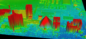
I downloaded LIDAR data from EarthExplorer -- focusing on downtown Las Vegas, specifically the pyramidal Luxor Hotel. The hotel's shape is so constraining that it needs specialized elevators, which tilt and shimmy, up to visitors' rooms. Of course, it is noteworthy to mention that LIDAR is also being utilized to search for ancient lost pyramids.
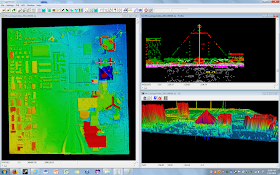
At first glance, the Luxor hotel is hard to pick out. However, increasing the point display size from the menu helps to highlight its unique shape. Alternatively, I could also have tried turning off some returns or chosen to highlight specific values for different LIDAR attributes. Redder points have higher elevation values. Click on the screenshots below to magnify them.
 |
| Can you see the Luxor Hotel? |
 |
| A slightly cleaned up 3-D view of the Luxor Hotel. |
 |
| How tall is the Luxor Hotel? Here, a quick measurement calculates about 105 meters-close to its actual 107m. |
 |
| NEW: LIDAR data with satellite imagery underneath. |
 |
| Google Street View of the Luxor and surrounding area |
See also:
FUSION Viewer
LIDAR Exercises

The use of LiDAR you need to know
ReplyDelete