LIDAR is an important technology that is undergoing continuous and expansive growth and predicted to reach $1 billion by 2020. A recent report also describes ongoing developments in LIDAR in Europe. NOAA has a great one-hour Introduction to LIDAR that I recommend checking out: http://coast.noaa.gov/digitalcoast/training/intro-lidar
 |
| Source: Allied Market Research, https://www.alliedmarketresearch.com/lidar-market |
Linking LAStools with QGIS
Linking the two has gotten much simpler since QGIS 2.4. Simply download the *.zip file from: http://lastools.org/download/lastools.zip. Unzip the file, and copy and past the LAStools folder into a simple directory like "c:/" If you have QGIS running, close it before proceeding.
Tip #1: Users often copy the folder to a folder pathway that is complex and includes spaces like c:/Program Files/ or c:/My Documents. It will not work. Again, use simple path names, no spaces!
Tip #2: This also applies for any files you import with LAStools or export during processing in QGIS.
After doing this, start QGIS, go to the Processing Toolbar, click "Tools for LiDAR Data"->Activate-> and enter or browse to the folder pathway. I've been using LAStools with the most recent version of QGIS (2.10) and have not had any problems yet.
 |
| Linking LAStools and QGIS has gotten much easier! |
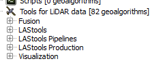 |
| Expand and see a wide range of tools at your disposal! Note: The LAStools Production or PRO tools are for batch processing. |
Tip #3: If you run a tool and nothing happens, be sure that NONE of the folder pathways, for importing data and exporting results, are complex and/or contain spaces.
Tip #4: Be sure to read the "Log" for important information and troubleshooting.

Tip #5: When using lasview in QGIS, pressing Space bar changes your ability to navigate from zoom, tilt,pan, and translate. In the upper-left of the window, you will see the navigation type change as you press it.
Furthermore, right-clicking the mouse, brings up a menu for changing the view of LIDAR, from selecting returns, how to symbolize/color data.
 |
| The right click menu in LAStools |
Tip #6: To get a 3D view, press Space bar until Pan is displayed, if is not already. Click and hold your mouse, then move it up to the top of the screen and voila!
 |
| Wizard Island, Crater Lake, Oregon, Data from: Open Topography. lasnoise was also used. |
OpenTopography
Digital Coast
3D Elevation Program
Google search for "County lidar" and State LIDAR
Thanks! That was very useful :)
ReplyDeleteThanks if there is something else you would like to see with LAStools or another program, feel free to leave it in the comments section below. - Jon
ReplyDeleteJohn,
DeleteThank you for these posts,
Do you think LAS tools work well with aerial imagery data that provide point cloud, as well?
Do these steps work on 2.12 Lyon? I thought I followed your instructions properly but the Tools for LiDAR data does not appear on the Processing Toolbox.
ReplyDeletefor 2.12..see follwing link: http://rapidlasso.com/2013/09/29/how-to-install-lastools-toolbox-in-qgis/
ReplyDeleteThanks for posting. Another resource I'd suggest for finding public domain lidar data (at least in the U.S.) is the U.S. Interagency Elevation Inventory (http://coast.noaa.gov/inventory). It's maintained by several federal agencies, but it has more than federal data in the inventory.
ReplyDeleteI can't get LAS tools to link to my QGIS. I'm using the most recent release: Qgis2.14.2-Essen. I tried putting the folder all over the place, even right in C:/. It never finds it. I copy in or browse to the location of the file, but it seems like it doesn't listen to me. I always get the same error: "Wrong value for parameter "Msys folder": Specified folder does not exis: c:/Progra~1/QGISES~1/apps\msys" I tried putting the folder where it seemed to be looking but that didn't work either. Also, I can't find anything called Msys.
ReplyDeleteI found a solution here: http://gis.stackexchange.com/questions/191590/qgis-2-14-1-lastools-install-error-wrong-value-for-parameter-msys-folder
DeleteThough I still can't get LAS tools to work, my new error is farther along...I think.
You can simply ignore the error message that goes something like:
ReplyDeleteWrong value for parameter "Msys folder": Specified folder ...
It has nothing to do with LAStools and your installation should still be fine.
Migrating from Windows to Linux Mint me how to set LAStools algorithms to work from QGIS in Linux
ReplyDeleteHi Jon,
ReplyDeleteI would like to know how to configure lastools in QGIS 2.18.3
Hi, I get the same error because of C:\Program Files, the space I think. Do I need to install QGIS 2.14.2 Essen directly on the C:\ as well?
ReplyDeleteThank you!
Lidar scanner is a surveying tool that can measure the length and distance of the earth's surface. Lidar can survey a large area within a short time. Onsite3D provides the best lidar scanning service at the best price. Lidar scanner Houston, Texas
ReplyDeleteThank you so much for this nice information.
ReplyDeletePeran dan Kegunaan Teknologi LiDAR di Berbagai Bidang