 |
| When I learn a new piece of software, I always go from left to right. |
The "File" menu allows you to import data, save and load projects (self-named *.gda files), and export selected data. In addition, there is a nice Project Information option that tells the title, data source and type, project name, number of observations and fields.
Data Formats
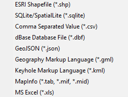
Users can import a wide array of file formats: shapefile, SQLite/SpatialLite, *.csv , .xls, .dbf, .json, .gml, .kml, and MapInfo files. Remember, are analyzing vector data, so points, lines, and polygons. Remember map projections matter, since spatial weights are created based on distance!
 |
| GeoDa does a great job of offering multiple file types to import. |
Spatial weights are used to model spatial relationships. Using GeoDa, we can create spatial weights based on contiguity/bordering (think chess moves: rook or queen), distance, and the number of nearest neighbors. Imagine a grid or matrix that has a row and column for every feature. The cells are populated using 0/1 for weights based on contiguity (where a feature borders another) or distances for distanced based weights.
Tips:
- Generally, do not go above 2nd order of contiguity: 1st order contiguity is neighbors, 2nd order is neighbors of neighbors. Anything beyond this becomes extremely difficult to interpret.
- The GeoDa Center also has PySAL an open source Python library that can be used to create spatial weights and perform spatial analysis.
- More about contiguity based spatial weights: https://geodacenter.asu.edu/node/380 and distance-based weights: https://geodacenter.asu.edu/node/384
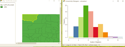
Another one of GeoDa's cool features is a histogram that shows the number of features with a specific number of features. It can also help you clear up any questions you have about different types of contiguity and how spatial relationships are modeled.
In case you tabular data, you can create points from this menu. You can also create a bounding box or grid. Next time, we'll look at the Table and Map toolbars.
Want blog or YouTube updates? You can follow me @jontheepi: https://twitter.com/jontheepi

Does it allowe to grab historical date directly from spredsheets to create graphs? eg: excel, open office
ReplyDeleteRegards,
Shalin @ creately
Yes, you can import spreadsheets and use the basic graphing functions under the "Explore" toolbar at the top.
ReplyDeleteHi John,
ReplyDeleteExcellent blog. Thanks for sharing.
www.vayamtech.com
Great Post,really it was very helpful for us.
ReplyDeleteThanks a lot for sharing!
I found this blog to be very useful!!
AWS Cloud training in Bangalore
Apa itu Geographic Calculator? Software Geodetik Global Mapper
ReplyDeleteCara Mudah Mendapatkan Visitor 1000 per Hari
ReplyDeleteI just got $1000/month from TikTok. Here is to Get money from TikTok by doing these tips. It works.
ReplyDeleteMindblowing, This is an amazing superb article Keep Sharing this...
ReplyDeleteThanks a lot!!!!
Germany VPS Hosting
Big Data Consultant lives in a world of bits and bytes, where no day is ever the same. The job is full of challenges, but it’s also full of fun. Every new project is a chance to learn something new and you never know who you’ll meet along the way. Big Data Consultant has a very specific set of skills that separates it from other jobs. It’s a job that you love or hate. If you’re not good at it, you might not last very long; if you are, you might make a good living for yourself.
ReplyDeleteHello, Nice post. After checking out a few of the articles on your web site, I seriously like your technique of blogging. I bookmarked it to my bookmark website list and will be checking back soon. Please visit my web site Datanest.earth. Best GIS Software Nz service provider.
ReplyDeleteNice blog keep posting.
ReplyDeletePython training institute in hyderabad
nice article
ReplyDeleteThis is a fantastic read! Your points are well-researched and clearly explained. I appreciate the time and effort you put into creating such informative content. Keep up the great work!
ReplyDeleteThis breakdown of GeoDa’s features is really insightful! The flexibility in importing various file formats and creating spatial weights based on contiguity or distance makes it a powerful tool for spatial analysis. The interactive maps and linked graphs also add a great layer of usability. Looking forward to more deep dives this series is incredibly helpful for anyone exploring open-source GIS tools.
ReplyDeleteAI Powered Digital Marketing Course In Hyderabad.
This is a fantastic overview of GeoDa’s capabilities! The support for multiple file formats and the interactive nature of linked maps and graphs make it a powerful tool for spatial data analysis. The explanation of spatial weights especially the rook and queen contiguity examples really helps visualize how relationships are modeled. Looking forward to more in this series.
ReplyDeleteAI Powered Digital Marketing Course In Hyderabad.
“Thank you for this post. It is easy to follow. I learned how to import data and use tools in GeoDa. Great work!”
ReplyDeleteGenerative AI Training In Hyderabad
Thank you for this insightful guide on importing data and utilizing tools in GeoDa. Your clear explanation of importing various file formats such as shapefiles, CSVs, and GeoJSONs, along with the creation of spatial weights based on contiguity and distance, provides a solid foundation for spatial data analysis. The interactive nature of GeoDa, where selecting features in one window highlights them in others, enhances the analytical experience.
ReplyDeleteAt Fast Prep Academy, we emphasize the importance of mastering spatial analysis tools like GeoDa to effectively interpret and visualize geospatial data. Your article serves as an excellent resource for learners aiming to deepen their understanding of spatial data analysis.
“This is an amazing overview of GeoDa’s features! Its support for multiple file formats and the interactive linked maps and graphs make it a really powerful tool for spatial analysis. The way you explained spatial weights—especially the rook and queen contiguity examples—makes the concepts so easy to visualize. Excited to see more in this series!”
ReplyDeleteThanks for the detailed post on spatial analysis using GeoDa! Your breakdown of spatial autocorrelation and its applications is very insightful. If you're also preparing for exams, I recommend checking out sat coaching online by Fast Prep Academy to stay organized and focused during your study sessions.
ReplyDeleteThis comment has been removed by the author.
ReplyDelete