Showing posts with label book review. Show all posts

Thursday, October 22, 2015

Book Review: An Introduction to R for Spatial Analysis and Mapping

I decided to talk a walk on the wild-side and examined R as a GIS for spatial analysis.  I hope to use several of R's spatial statistics packages and to automate tasks--staying within one program.  I highly recommend Brunsdon and Comber's book ($50 on Amazon, Paperback, electronic versions also available).

About the Authors: Chris Brunsdon is the creator of geographically weighted regression or GWR. Lex Comber is a professor at Leeds University.

Four Reasons to choose R as a GIS
1)  You are interested in performing tailored exploratory spatial data analysis (ESDA), spatial statistics, regression analysis, and diagnostics.
  • Of course, R is also way better than ArcGIS and QGIS for summary statistics too. (Notably, QGIS has integrated a R processing toolbox into it. ArcGIS  also has an official bridge to R.)
2)  You already use R for non-spatial data, have lots of code written, and need to analyze spatial data.

3)  You do not want to export your data (or results) from one program into another and back again!

4) You want to be able to publish or share your code with a wider audience.

A great cover to a great book!
Reader Accessibility
The content is extremely well-presented, clear and concise, and includes color graphics. It is not overly technical. Still, R as a GIS and spatial analysis are tough material and is definitely not for the faint-of-heart. The authors assume readers may not have either a R or GIS background, or both. I took a R class in graduate school and occasionally use it.

Additional packages that assist in manipulating and reshaping data, such as plyr, are also discussed. The authors also warn readers that R packages can change over time, causing error messages, but many warn users about recent and upcoming changes.

Overview
In the first 40 pages, you will learn R basics, if you don't already have a foundation. Next, you will learn GIS fundamentals, how to plot data to create a map, taking into account scale, and adding and positioning common map elements like a north arrow and scale bar. This may sound basic but in R nothing is easy!  Of course, the advantage with code is that you can reuse it or may only need to modify it slightly for many maps.

Late in Chapter 5-6 the book dives into spatial analysis.  The last few chapters are probably the best of the book, as more advanced statistical techniques are discussed including local indicators of spatial auto correlation (LISAs), geographically weighted summary statistics and regression.

The book providers a great guide and reference, and I am sure I will be re-visiting it frequently!  Overall, it is a great mix of practice and theory.

Disclosures: 
None, I found and purchased the book on my own.

Monday, June 29, 2015

Book Review: PostGIS Essentials

I decided to teach myself PostGIS/PostgreSQL.  The other option was returning to GeoServer, which I started last summer, but I will leave the latter for the fall.

After shopping around and reading reader reviews, I purchased PostGIS Essentials, April 2015 by Angel Marquez. I got a Kindle copy which was $22 on Amazon.  Overall, I recommend it for those, like me, who want to learn PostGIS as a beginner. Having even a little SQL knowledge is also very helpful.  However, the later chapters are for much more advanced users and developing web and desktop applications.

The book covers downloading and installing PostGIS and gives a good quick background on its uses. Next, it illustrates three ways to create a spatial database using: 1) the command prompt, 2) the toolbars or GUI in PostGIS, and 3) a SQL script.  

A great way to learn PostGIS/PostgreSQL
Before covering how to insert data into these tables, the book goes into discussion of projections and how to include these in spatial tables.  It then shows how to manually add this information and also extract it from shapefiles and import it into PostGIS.

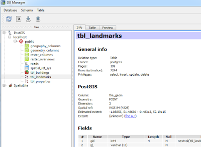
Next, we get down to business with creating non-spatial and spatial queries/functions and accessing information from more than one database.  Of course, connecting to PostGIS databases in QGIS is also covered as well as doing spatial queries in QGIS using PostGIS using DB Manager toolbar in QGIS.

Going from PostGIS to QGIS is a snap!
Using DB Manager from the database toolbar in QGIS.

You will also find information on GDAL, working with raster files.  The last few chapters cover advanced features including performance tuning and spatial indexes, developing web and desktop GIS applications.  The latter uses NASA World Wind.  (Note: I have only had time to skim these chapters.)

A few quick pointers

  • Early on the book assumes the reader knows where to execute SQL queries..If you are a novice like me it takes a minute to realize it is the magnifying glass 
  • ...and how to switch to a different database table when running code on several different ones. 

  • Be sure to check the column names in data from OpenStreetMap, particularly the id column: osm_id vs. id.
Overall, the book is a great resource to have. Like all of Packt's books the code is available to download on their website, or you can type it in yourself, which is my preference.

Disclosures
I bought the copy of this book on my own.  I served as a reviewer for another Packt publication.

Sunday, December 1, 2013

Book Review: Learning QGIS 2.0

The best place to discover QGIS is "Learning QGIS 2.0" by Anita Graser for its brevity and attention to detail.  Making great maps using QGIS, a free and open source desktop GIS, is only a few steps away using this book.  Released in September 2013, it is the most up-to-date reference on how to get the results you want using QGIS.  I finally had a chance to read the e-book in its entirety and here is what I think.

The book was written for a range of audiences--including newcomers and more seasoned veterans.  It covers basic and advanced topics from installing QGIS, whether a user or developer and  Ubuntu/Linux or Windows, to adding and editing map data.  In addition, the book contains color screenshots to illustrate what actions are being performed.

The book proceeds logically and words are used efficiently. It helps users add different types of GIS-related data, understand how QGIS treats projections, and highlights vital mapmaking tasks such as symbolizing and labeling.   It also covers QGIS' plugins, notably the Open Street Map plugin for using common basemaps and the Heatmap plugin for density analysis.

Later topics include using the Map Composer (analogous to Layout View in ArcGIS) and the Graphical modeler (Model Builder in ArcGIS). 

Two potential criticisms of open source software are that they tend be harder to use than their paid counterparts.  In addition, some programs lack easy-to-read and authoritative documentation.  With "Learning QGIS 2.0", these barriers no longer exist.   The timing of the book could not be more perfect with the release of QGIS 2.0 Dufour.

When you finish the book, be sure to visit Anita Graser's blog at: http://anitagraser.com/.  It is a real treat!  There you can gain even more advanced knowledge.

To purchase Learning QGIS 2.0 visit Packt Publishing or Amazon.com and Kindle.  The book is available both in e-book formats and physical paper copies/softcover.  E-book formats run about $12.  You can also get a physical copy of the book and all e-book formats for ~$25 on the publisher's site.  Released Sept 2013, 110 pages.

Available from Packt Publishing and Amazon/Amazon Kindle