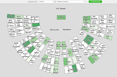
How does Atlasify do this? Well, it uses semantic relatedness--basically a scoring system to be able to pair and match things that are related. Visualization options include: mapping/geography, chemistry/a periodic table, politics/senate seating chart, and history/a timeline.
If you are having trouble thinking about this, thats okay! Let's go through a couple of examples. Be sure to click each map to make it larger.
First an easy one: the geography of nuclear weapons. Note the key in the bottom right-hand corner. Some countries are obviously more closely related to nuclear weapons (those that have, thought to possess, or are pursuing that technology).
First an easy one: the geography of nuclear weapons. Note the key in the bottom right-hand corner. Some countries are obviously more closely related to nuclear weapons (those that have, thought to possess, or are pursuing that technology).
 |
| Some countries are more related to the search term nuclear weapons than others. |
Lets look at another example, which is still spatial, but uses senates seat locations. See the example below which looks at the relatedness between medical marijuana and senate seats. Some senators are more closely tied to the issue, whether pursing legislation for or against. Some of those senators even sit near each other or across the aisle.
 |
| Some senators are more related to the issues of medical marijuana than others. |
Lastly, Atlasify has a little fun gaming component which asks which of two items are more related to certain countries: http://spatialization.cs.umn.edu/game/index.html
Interested learning more about spatial computing? Be sure to check out my review of the Coursera course from the University of Minnesota:http://opensourcegisblog.blogspot.com/2014/12/review-of-spatial-computing-class-on.html.

No comments:
Post a Comment