Quick Background on Orfeo Toolbox
The toolbox, often abbreviated OTB, was created to promote the use of several French satellites. Like many programs, the algorithms are geared towards popular satellites. For more on its creation, visit: http://www.orfeo-toolbox.org/otb/about-otb.html.
In QGIS
After following the instructions above, go under "Processing" and make sure the "Toolbox" is selected. You will see Orfeo's tools grouped into what types of functions they perform.
 |
| Screenshot of Orfeo Toolbox in QGIS's Processing Toolbox |
Extracting features from imagery is an extremely powerful tool. For example, roads can be extracted from imagery. Edges of images and line segments can be detected. They can a provide a quick unique source of data for areas large and small. Click on any of the images below to get a closer look.
 |
| Extracted edges of buildings at a college campus. |
 |
| Line segment detection: In this case the lines of a tennis court (and fencing). The tan lines are generated by the software. |
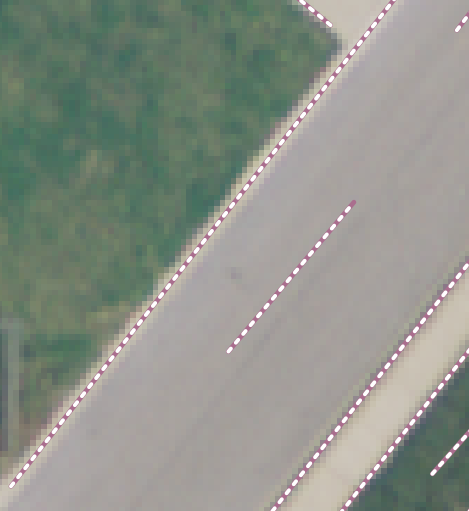 |
| Line segments differentiating a road, sidewalk, and nearby grass. |
Change Detection
Another important aspect of imagery is detecting changes over time, whether something is new, absent, modified, or (re)moved.
 |
| Left: Unpainted roof, Center: Roof painted red, Right: Change Detection of Roof |
Remote sensing and image processing are technical fields. There is a significant amount of documentation (hundreds of pages) on the Orfeo Toolbox website. A shortened manual and a series of short practical exercises could help to expand its user base. If you work in remote sensing and image processing, be sure to check out this fantastic resource!
Thanks a lot... from Chile.
ReplyDeleteI am trying config otb in QGIS 2.18.0 but I can't I need help please
ReplyDeletecan you post info in detail on how to extract a feature like roads
ReplyDelete